Geolocate

Bole topographic map

Click on the map to display elevation.

About this map

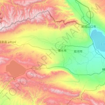
Name: Bole topographic map, elevation, terrain.

Location: Bole, Bortala Mongol Autonomous Prefecture, Xinjiang, China (44.12024 81.17150 45.52024 82.57150)

Average elevation: 1,456 m

Minimum elevation: 193 m

Maximum elevation: 4,081 m

Gear up for your next adventure:

Altimeter Watches - Watches with altitude tracking
🔦Powerful LED Headlamps - Hands-free lighting for night navigation and setting up camp after dark
🥾Trail Running Shoes - Shoes for trail running
🪫Rechargeable Headlamps - USB rechargeable headlamps
🧣Merino Neck Gaiters - Versatile headwear for warmth, sun protection, or dust filtering

As an Amazon Associate, this site earns from qualifying purchases at no extra cost to you.