
Make a donation
Gear up for your next adventure:
As an Amazon Associate, this site earns from qualifying purchases at no extra cost to you.
Mount David topographic map
Click on the map to display elevation.
Make a donation
Gear up for your next adventure:
As an Amazon Associate, this site earns from qualifying purchases at no extra cost to you.
Mount David
Mount David is a prominent 7,420-foot (2,260-metre) mountain summit located in Chelan County of Washington state. The mountain is situated in the Glacier Peak Wilderness, on land managed by the Okanogan-Wenatchee National Forest. Mount David is the highest point of Wenatchee Ridge, a subrange which also includes Indian Head Peak, Whittier Peak, Mount Saul, and Mount Jonathan. Its nearest higher neighbor is Bandit Peak, 5.69 mi (9.16 km) to the east-northeast. Precipitation runoff from Mount David drains into tributaries of the White River. Although modest in elevation, relief is significant since Mt. David rises 5,100 feet above the White River Valley in two miles. This peak was named for the biblical David by Albert Hale Sylvester, a pioneer surveyor, explorer, topographer, and forest supervisor in the Cascades who named thousands of natural features. This mountain can be climbed via the strenuous seven-mile Mount David Trail with over 5,000 feet of elevation gain.
Make a donation
Gear up for your next adventure:
As an Amazon Associate, this site earns from qualifying purchases at no extra cost to you.
About this map
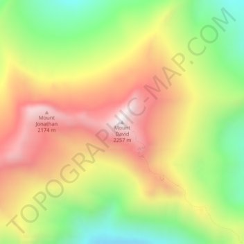
Name: Mount David topographic map, elevation, terrain.
Location: Mount David, Chelan County, Washington, United States (47.96284 -120.98987 47.96294 -120.98977)
Average elevation: 1,736 m
Minimum elevation: 1,247 m
Maximum elevation: 2,224 m
Make a donation
Gear up for your next adventure:
As an Amazon Associate, this site earns from qualifying purchases at no extra cost to you.
Other topographic maps
Click on a map to view its topography, its elevation and its terrain.
Lake Chelan
United States > Washington > Chelan County > Chelan
Lake Chelan (/ʃəˈlæn/ shə-LAN) is a narrow, 50.5 mi (81.3 km) long lake in Chelan County, north-central Washington state, U.S. It is an overdeepened lake and resembles a fjord, with an average width of 1.3 mi (2.1 km). Near its upper end, the lake surface lies more than 6,600 ft (2,000 m) below peaks less…
Average elevation: 1,358 m