Geolocate

Whitewater topographic map

Click on the map to display elevation.

About this map

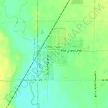
Name: Whitewater topographic map, elevation, terrain.

Location: Whitewater, Butler County, Kansas, United States (37.95651 -97.15259 37.96927 -97.13652)

Average elevation: 419 m

Minimum elevation: 408 m

Maximum elevation: 430 m

Other topographic maps

Click on a map to view its topography, its elevation and its terrain.

Prospect

United States > Kansas > Butler County

Average elevation: 417 m

Gear up for your next adventure:

📻Handheld UHF Radios - Critical communication for groups in the Australian outback
🧼Clip-on Hand Sanitizer - Maintain hygiene when water for washing is scarce
🌧️Rain Jackets - Waterproof jackets for hiking
🩹First Aid Kits - Emergency kits for hiking
🔋Solar Power Banks - Solar chargers for outdoors

As an Amazon Associate, this site earns from qualifying purchases at no extra cost to you.