
Make a donation
Gear up for your next adventure:
As an Amazon Associate, this site earns from qualifying purchases at no extra cost to you.
Grünstein topographic map
Click on the map to display elevation.
Make a donation
Gear up for your next adventure:
As an Amazon Associate, this site earns from qualifying purchases at no extra cost to you.
Grünstein
Der bequemste Weg führt vom Parkplatz Hammerstiel in der Oberschönau vorbei an der bewirtschafteten Grünsteinhütte auf 1220 m Höhe zum Gipfel. Ein weiterer Weg führt steiler und etwas alpiner vom Königssee entlang der Kunsteis-Rodelbahn weiter zur Grünsteinhütte und vereinigt sich dann mit dem ersten Weg. Die Aufstiegszeit beträgt jeweils ca. 1½ Stunden.
Make a donation
Gear up for your next adventure:
As an Amazon Associate, this site earns from qualifying purchases at no extra cost to you.
About this map
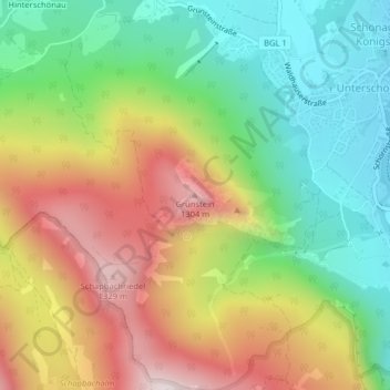
Name: Grünstein topographic map, elevation, terrain.
Average elevation: 903 m
Minimum elevation: 575 m
Maximum elevation: 1,343 m
Make a donation
Gear up for your next adventure:
As an Amazon Associate, this site earns from qualifying purchases at no extra cost to you.
Other topographic maps
Click on a map to view its topography, its elevation and its terrain.
Funtensee
Deutschland > Bayern > Landkreis Berchtesgadener Land > Schönau am Königssee
Der Funtensee ist ein Karstsee im Gebirgsmassiv des Steinernen Meeres im Nationalpark Berchtesgaden und liegt auf einer Höhe von 1601 m ü. NHN. Überregionale Bekanntheit hat der See durch seine lagebedingten Kälterekorde erlangt, die jedoch für die weitere Umgebung nicht repräsentativ sind.
Average elevation: 1,813 m
Eisgraben
Deutschland > Bayern > Landkreis Berchtesgadener Land > Schönau am Königssee
Average elevation: 1,260 m