
Make a donation
Gear up for your next adventure:
As an Amazon Associate, this site earns from qualifying purchases at no extra cost to you.
Wolfegg topographic map
Click on the map to display elevation.
Make a donation
Gear up for your next adventure:
As an Amazon Associate, this site earns from qualifying purchases at no extra cost to you.
About this map
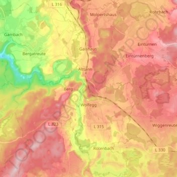
Name: Wolfegg topographic map, elevation, terrain.
Average elevation: 664 m
Minimum elevation: 515 m
Maximum elevation: 765 m
Make a donation
Gear up for your next adventure:
As an Amazon Associate, this site earns from qualifying purchases at no extra cost to you.
Other topographic maps
Click on a map to view its topography, its elevation and its terrain.
Hopfenweiler
Germany > Baden-Württemberg > Landkreis Ravensburg > Bad Waldsee
Average elevation: 618 m
Deuchelried
Germany > Baden-Württemberg > Landkreis Ravensburg > Wangen im Allgäu
Average elevation: 604 m
Urlau
Germany > Baden-Württemberg > Landkreis Ravensburg > Leutkirch im Allgäu > Urlau
Average elevation: 698 m
Make a donation
Gear up for your next adventure:
As an Amazon Associate, this site earns from qualifying purchases at no extra cost to you.