
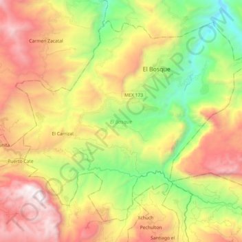
El Bosque topographic map
Interactive map
Click on the map to display elevation.
About this map
Name: El Bosque topographic map, elevation, terrain.
Location: El Bosque, Chiapas, México (16.95383 -92.82550 17.09619 -92.64628)
Average elevation: 1,315 m
Minimum elevation: 339 m
Maximum elevation: 2,472 m
Other topographic maps
Click on a map to view its topography, its elevation and its terrain.
San Pedro Michocán
México > Chiapas > Las Margaritas
San Pedro Michocán, Las Margaritas, Chiapas, México
Average elevation: 679 m
Veintiséis de Octubre
México > Chiapas > Chiapa de Corzo
Veintiséis de Octubre, Chiapa de Corzo, Chiapas, México
Average elevation: 446 m
26 de Octubre
26 de Octubre, Tapachula, Chiapas, México
Average elevation: 744 m
Parque ecologico Tapachula
Parque ecologico Tapachula, Fracc. Valle Verde, Tapachula, Chiapas, México
Average elevation: 115 m
Nuevo Eden
México > Chiapas > Tuxtla Gutiérrez > Nuevo Eden
Nuevo Eden, Tuxtla Gutiérrez, Chiapas, 29057, México
Average elevation: 678 m
Rio de Janeiro
México > Chiapas > Rio de Janeiro
Rio de Janeiro, La Trinitaria, Chiapas, México
Average elevation: 829 m