
Lunery topographic map
Interactive map
Click on the map to display elevation.
About this map
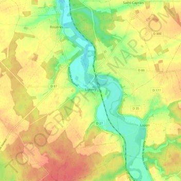
Name: Lunery topographic map, elevation, terrain.
Average elevation: 152 m
Minimum elevation: 122 m
Maximum elevation: 176 m
Other topographic maps
Click on a map to view its topography, its elevation and its terrain.
Achères
France > Centre-Val de Loire > Cher
Achères, Bourges, Cher, Centre-Val de Loire, France métropolitaine, 18250, France
Average elevation: 262 m
Avord
France > Centre-Val de Loire > Cher
Avord, Bourges, Cher, Centre-Val de Loire, France métropolitaine, 18520, France
Average elevation: 174 m
Ivry
France > Centre-Val de Loire > Cher > Vasselay
Ivry, Vasselay, Bourges, Cher, Centre-Val de Loire, France métropolitaine, 18110, France
Average elevation: 159 m
Cornusse
France > Centre-Val de Loire > Cher > Cornusse
Cornusse, Saint-Amand-Montrond, Cher, Centre-Val de Loire, France métropolitaine, 18350, France
Average elevation: 194 m
Rians
France > Centre-Val de Loire > Cher > Rians
Rians, Bourges, Cher, Centre-Val de Loire, France métropolitaine, 18220, France
Average elevation: 186 m