
Make a donation
Gear up for your next adventure:
As an Amazon Associate, this site earns from qualifying purchases at no extra cost to you.
Hastinapur topographic map
Click on the map to display elevation.
Make a donation
Gear up for your next adventure:
As an Amazon Associate, this site earns from qualifying purchases at no extra cost to you.
Hastinapur
Present-day Hastinapur is a town in the Doab region of Uttar Pradesh in India, about 37 kilometres (23 mi) from Meerut and nearly 96 km (60 mi) north-east of Delhi on National Highway 34. It is a small township re-established by Jawaharlal Nehru on February 6, 1949, located at 29°10′N 78°01′E / 29.17°N 78.02°E / 29.17; 78.02. With an average elevation of 218 metres (715 ft), Hastinapur experiences temperatures ranging from 5 to 40 °C (41 to 104 °F). Summer season is from March to May, during which the temperatures range from 32 to 40 °C (90 to 104 °F). The monsoon season is from July to September, during which the temperature is relatively low. Winter lasts from December to February, with December usually being the coldest month of the year. During this time, temperatures can drop to around 5 °C (41 °F) and don't usually go above 14 °C (57 °F).
Make a donation
Gear up for your next adventure:
As an Amazon Associate, this site earns from qualifying purchases at no extra cost to you.
About this map
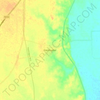
Name: Hastinapur topographic map, elevation, terrain.
Average elevation: 226 m
Minimum elevation: 211 m
Maximum elevation: 239 m
Make a donation
Gear up for your next adventure:
As an Amazon Associate, this site earns from qualifying purchases at no extra cost to you.