
Thank you for supporting this site ❤️
Make a donation
Make a donation
Gear up for your next adventure:
As an Amazon Associate, this site earns from qualifying purchases at no extra cost to you.
Vale Perkins topographic map
Click on the map to display elevation.
Thank you for supporting this site ❤️
Make a donation
Make a donation
Gear up for your next adventure:
As an Amazon Associate, this site earns from qualifying purchases at no extra cost to you.
About this map
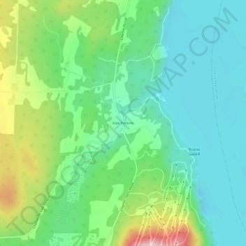
Name: Vale Perkins topographic map, elevation, terrain.
Location: Vale Perkins, Potton, Memphrémagog, Estrie, Quebec, Canada (45.06822 -72.32401 45.10822 -72.28401)
Average elevation: 287 m
Minimum elevation: 191 m
Maximum elevation: 522 m
Thank you for supporting this site ❤️
Make a donation
Make a donation
Gear up for your next adventure:
📣High-Decibel Survival Whistles - Signaling tool for rescue that carries much further than a human voice
🛰️Handheld GPS Units - Rugged GPS devices for tracking coordinates and elevation in the Australian bush
As an Amazon Associate, this site earns from qualifying purchases at no extra cost to you.