Geolocate

La Bourdette topographic map

Interactive map

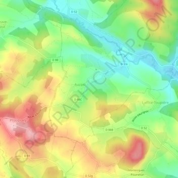
Click on the map to display elevation.

About this map

Name: La Bourdette topographic map, elevation, terrain.

Location: La Bourdette, Auzas, Saint-Gaudens, Haute-Garonne, Occitanie, France métropolitaine, 31360, France (43.14809 0.86572 43.18809 0.90572)

Average elevation: 377 m

Minimum elevation: 296 m

Maximum elevation: 476 m

Other topographic maps

Click on a map to view its topography, its elevation and its terrain.

Gnotes

France > Occitanie > Haute-Garonne > Auzas > Gnotes

Gnotes, Auzas, Saint-Gaudens, Haute-Garonne, Occitanie, France métropolitaine, 31360, France

Average elevation: 367 m

Carret

France > Occitanie > Haute-Garonne > Auzas > Carret

Carret, Auzas, Saint-Gaudens, Haute-Garonne, Occitanie, France métropolitaine, 31360, France

Average elevation: 385 m

Gnotes

France > Occitanie > Haute-Garonne > Auzas

Gnotes, Auzas, Saint-Gaudens, Haute-Garonne, Occitanie, France métropolitaine, 31360, France

Average elevation: 369 m