
Holybourne topographic map
Click on the map to display elevation.
About this map
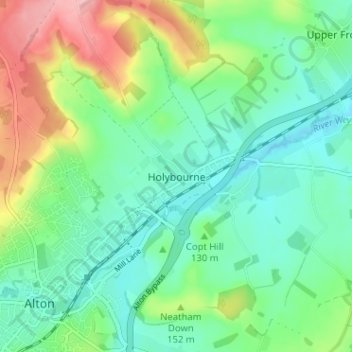
Name: Holybourne topographic map, elevation, terrain.
Average elevation: 131 m
Minimum elevation: 89 m
Maximum elevation: 224 m
Other topographic maps
Click on a map to view its topography, its elevation and its terrain.
Rowlands Castle
United Kingdom > England > Hampshire > East Hampshire > Finchdean
Average elevation: 72 m
Four Marks
United Kingdom > England > Hampshire > East Hampshire > Four Marks
Average elevation: 185 m
Rowland's Copse, Red Hill
United Kingdom > England > Hampshire > East Hampshire > Rowlands Castle
Average elevation: 42 m
Newton Valence
United Kingdom > England > Hampshire > East Hampshire
The village sits high in the westernmost chalk hills of the South Downs: maximum elevation 191 metres (627 feet) above sea level. Much of the surrounding landscape is within the East Hampshire Area of Outstanding Natural Beauty.
Average elevation: 153 m
Comp
United Kingdom > England > Hampshire > East Hampshire > Upper Farringdon
Average elevation: 126 m
Bramshott Common
United Kingdom > England > Hampshire > East Hampshire > Bramshott
Average elevation: 148 m
Havant Thicket
United Kingdom > England > Hampshire > East Hampshire > Rowlands Castle
Average elevation: 48 m
Ludshott Common
United Kingdom > England > Hampshire > East Hampshire > Bramshott
Average elevation: 162 m
Farringdon
United Kingdom > England > Hampshire > East Hampshire > Lower Farringdon
Average elevation: 153 m
Ditcham Woods.
United Kingdom > England > Hampshire > East Hampshire > Buriton
Average elevation: 136 m
Shalden
United Kingdom > England > Hampshire > East Hampshire
Shalden is a village and civil parish in the East Hampshire district of Hampshire, England. It is 2.3 miles (3.7 km) northwest of Alton and 1.9 miles (3.1 km) northeast of Bentworth, just off the A339 road. The parish covers an area of 1,536 acres (622 ha) and has an average elevation of 600 feet (180 m) above…
Average elevation: 177 m
Queen Elizabeth Country Park
United Kingdom > England > Hampshire > East Hampshire > Buriton
Average elevation: 151 m
Medstead
United Kingdom > England > Hampshire > East Hampshire
Medstead is a village and civil parish in the East Hampshire district of Hampshire, England. Its nearest town is Alton, which lies 4.3 miles (6.9 km) northeast of the village. According to the 2011 census, the village had a population of 2,036 people. The parish covers an area of 1,536 acres (622 ha) and has…
Average elevation: 186 m
East Tisted
United Kingdom > England > Hampshire > East Hampshire > East Tisted
Average elevation: 171 m
Lasham
United Kingdom > England > Hampshire > East Hampshire
The parish covers an area of 1,797 acres (727 ha) and has an average elevation of 560 feet (170 m) above sea level. The nearest railway station is Alton, 3.5 miles (5.6 km) southeast of the village. Lasham formerly had its own railway station, Bentworth and Lasham, on the Basingstoke and Alton Light Railway…
Average elevation: 168 m
Medstead
United Kingdom > England > Hampshire > East Hampshire
Medstead is a village and civil parish in the East Hampshire district of Hampshire, England. Its nearest town is Alton, which lies 4.3 miles (6.9 km) northeast of the village. According to the 2011 census, the village had a population of 2,036 people. The parish covers an area of 1,536 acres (622 ha) and has…
Average elevation: 186 m
Rowlands Castle
United Kingdom > England > Hampshire > East Hampshire > Finchdean
Average elevation: 72 m