Geolocate

Manor topographic map

Click on the map to display elevation.

About this map

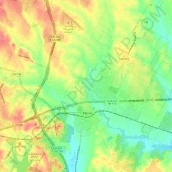
Name: Manor topographic map, elevation, terrain.

Location: Manor, Travis County, Texas, 78653, United States (30.32814 -97.57634 30.38871 -97.45632)

Average elevation: 171 m

Minimum elevation: 141 m

Maximum elevation: 206 m

Other topographic maps

Click on a map to view its topography, its elevation and its terrain.

Gus Fruh Park

United States > Texas > Travis County > Austin

Average elevation: 194 m

Mayfield Park

United States > Texas > Travis County > Austin

Average elevation: 180 m

Onion Creek

United States > Texas > Travis County > Austin

Average elevation: 162 m

Pilot Knob

United States > Texas > Travis County

Average elevation: 166 m

Nameless

United States > Texas > Travis County > Leander

Average elevation: 277 m

Steiner Ranch

United States > Texas > Travis County

Average elevation: 221 m

Austin

United States > Texas > Travis County > Austin

The elevation of Austin varies from 425 feet (130 m) to approximately 1,000 feet (305 m) above sea level. Due to the fact it straddles the Balcones Fault, much of the eastern part of the city is flat, with heavy clay and loam soils, whereas the western part and western suburbs consist of rolling hills on the…

Average elevation: 203 m

Davis Hill

United States > Texas > Travis County > Austin

Average elevation: 241 m

Barton Creek

United States > Texas > Travis County

Average elevation: 247 m

White Rim Mountain

United States > Texas > Travis County

Average elevation: 259 m

Turkey Creek

United States > Texas > Travis County > Austin

Average elevation: 198 m

Sprinkle Corner

United States > Texas > Travis County > Austin

Average elevation: 202 m

Nameless

United States > Texas > Travis County > Leander

Average elevation: 277 m

Barton Creek

United States > Texas > Travis County > Austin

Average elevation: 155 m

Mount Bonnell

United States > Texas > Travis County > Austin

Average elevation: 189 m

Mount Lucas

United States > Texas > Travis County > Austin

Average elevation: 196 m

Gear up for your next adventure:

🍳Ultralight Camping Stoves - Boil water quickly for meals using minimal fuel
🧥Packable Rain Jackets - Breathable waterproof layers for unpredictable mountain weather
🩹Blister Prevention Tape - Apply to friction points before they become painful sores
👄SPF Lip Balm - Prevent sun and wind-burnt lips on mountain ridges
🧢Wide Brim Sun Hats - Maximum coverage for the face and neck while out in the open

As an Amazon Associate, this site earns from qualifying purchases at no extra cost to you.