
Make a donation
Gear up for your next adventure:
As an Amazon Associate, this site earns from qualifying purchases at no extra cost to you.
Poperinge topographic map
Click on the map to display elevation.
Make a donation
Gear up for your next adventure:
As an Amazon Associate, this site earns from qualifying purchases at no extra cost to you.
About this map
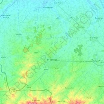
Name: Poperinge topographic map, elevation, terrain.
Location: Poperinge, Ieper, West Flanders, Flanders, Belgium (50.79481 2.59864 50.93725 2.80341)
Average elevation: 23 m
Minimum elevation: -1 m
Maximum elevation: 105 m
Make a donation
Gear up for your next adventure:
As an Amazon Associate, this site earns from qualifying purchases at no extra cost to you.
Other topographic maps
Click on a map to view its topography, its elevation and its terrain.
Polderhoek
Belgium > West Flanders > Ieper > Zonnebeke > Geluveld > Poezelhoek
Average elevation: 45 m
Make a donation
Gear up for your next adventure:
As an Amazon Associate, this site earns from qualifying purchases at no extra cost to you.