Geolocate

Bomerano topographic map

Click on the map to display elevation.

About this map

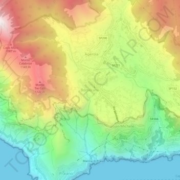
Name: Bomerano topographic map, elevation, terrain.

Location: Bomerano, Agerola, Naples, Campania, 80051, Italy (40.60970 14.51836 40.64970 14.55836)

Average elevation: 579 m

Minimum elevation: -1 m

Maximum elevation: 1,357 m

Other topographic maps

Click on a map to view its topography, its elevation and its terrain.

Naples

Italy > Campania > Naples

In 1755, the Duke of Noja commissioned an accurate topographic map of Naples, later known as the Map of the Duke of Nojo, employing rigorous surveying accuracy and becoming an essential urban planning tool for Naples.

Average elevation: 65 m

Capri

Italy > Campania > Naples > Anacapri

Average elevation: 55 m

Sorrento

Italy > Campania > Naples

Average elevation: 196 m

Santa Maria la Carità

Italy > Campania > Naples

Average elevation: 20 m

Isola la Gaiola

Italy > Campania > Naples > Naples > Coroglio

Average elevation: 19 m

Sorrento

Italy > Campania > Naples

Average elevation: 196 m

Vico Equense

Italy > Campania > Naples

Winters are mild and damp, lasting from early December to early/mid March. Rainfall ranges from common to abundant and the temperatures hover around 6 °C-12 °C (mid 40s or low 50s) at night and around 10 °C-16 °C (50s°F) during the day. It is common to have sunny and mild days even in the middle of…

Average elevation: 229 m

Sorrento

Italy > Campania > Naples

Average elevation: 196 m

Naples

Italy > Campania > Naples

In 1755, the Duke of Noja commissioned an accurate topographic map of Naples, later known as the Map of the Duke of Nojo, employing rigorous surveying accuracy and becoming an essential urban planning tool for Naples.

Average elevation: 65 m

Capri

Italy > Campania > Naples > Anacapri

Average elevation: 55 m

Acerra

Italy > Campania > Naples

Average elevation: 27 m

Naples

Italy > Campania > Naples

In 1755, the Duke of Noja commissioned an accurate topographic map of Naples, later known as the Map of the Duke of Noja, employing rigorous surveying accuracy and becoming an essential urban planning tool for Naples.

Average elevation: 65 m

Pozzuoli

Italy > Campania > Naples

Average elevation: 74 m

Naples

Italy > Campania > Naples

In 1755, the Duke of Noja commissioned an accurate topographic map of Naples, later known as the Map of the Duke of Noja, employing rigorous surveying accuracy and becoming an essential urban planning tool for Naples.

Average elevation: 65 m

Naples

Italy > Campania > Naples

In 1755, the Duke of Noja commissioned an accurate topographic map of Naples, later known as the Map of the Duke of Noja, employing rigorous surveying accuracy and becoming an essential urban planning tool for Naples.

Average elevation: 65 m

Naples

Italy > Campania > Naples

In 1755, the Duke of Noja commissioned an accurate topographic map of Naples, later known as the Map of the Duke of Noja, employing rigorous surveying accuracy and becoming an essential urban planning tool for Naples.

Average elevation: 65 m

Naples

Italy > Campania > Naples

In 1755, the Duke of Noja commissioned an accurate topographic map of Naples, later known as the Map of the Duke of Noja, employing rigorous surveying accuracy and becoming an essential urban planning tool for Naples.

Average elevation: 65 m

Naples

Italy > Campania > Naples

In 1755, the Duke of Noja commissioned an accurate topographic map of Naples, later known as the Map of the Duke of Noja, employing rigorous surveying accuracy and becoming an essential urban planning tool for Naples.

Average elevation: 65 m

Pompei

Italy > Campania > Naples

Average elevation: 15 m

Capri

Italy > Campania > Naples > Anacapri

Average elevation: 55 m

Naples

Italy > Campania > Naples

In 1755, the Duke of Noja commissioned an accurate topographic map of Naples, later known as the Map of the Duke of Noja, employing rigorous surveying accuracy and becoming an essential urban planning tool for Naples.

Average elevation: 65 m

Pompei

Italy > Campania > Naples

Average elevation: 15 m

Ischia

Italy > Campania > Naples

Average elevation: 98 m

Procida

Italy > Campania > Naples

Average elevation: 7 m

Gear up for your next adventure:

📱Tablet Tripod Mounts - Steady platforms for viewing digital maps or taking long exposures
📦Crushproof Equipment Cases - Safe transport for sensitive surveying and mapping instruments
🧥Softshell Jackets - Flexible outdoor jackets
Ultralight Solo Tents - Compact shelters for multi-day topographic surveying expeditions
🚴Bike GPS - GPS devices for cycling

As an Amazon Associate, this site earns from qualifying purchases at no extra cost to you.