
Kitimat topographic map
Click on the map to display elevation.
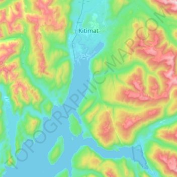
About this map
Name: Kitimat topographic map, elevation, terrain.
Average elevation: 445 m
Minimum elevation: -2 m
Maximum elevation: 1,843 m
Other topographic maps
Click on a map to view its topography, its elevation and its terrain.
Ball Creek
Canada > British Columbia > Regional District of Kitimat-Stikine > Area D (Iskut/Big Raven)
Average elevation: 1,231 m
Mount Barrington
Canada > British Columbia > Regional District of Kitimat-Stikine > Area D (Iskut/Big Raven)
Average elevation: 1,437 m
40 Mile Flats
Canada > British Columbia > Regional District of Kitimat-Stikine > Area D (Iskut/Big Raven)
Average elevation: 1,105 m