
Playa Platanales topographic map
Interactive map
Click on the map to display elevation.
About this map
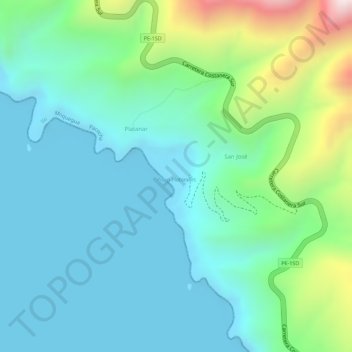
Name: Playa Platanales topographic map, elevation, terrain.
Location: Playa Platanales, PE-1SD, Pacocha, Ilo, Moquegua, Perú (-17.39088 -71.39733 -17.38613 -71.39263)
Average elevation: 141 m
Minimum elevation: 0 m
Maximum elevation: 570 m
Other topographic maps
Click on a map to view its topography, its elevation and its terrain.
Pueblo Nuevo
Perú > Moquegua > Pacocha > Pueblo Nuevo
Pueblo Nuevo, Pacocha, Provincia de Ilo, Moquegua, 18601, Perú
Average elevation: 60 m