
Richlands topographic map
Interactive map
Click on the map to display elevation.
About this map
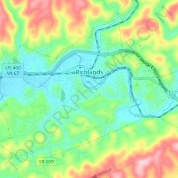
Name: Richlands topographic map, elevation, terrain.
Location: Richlands, Tazewell County, Virginia, United States (37.06739 -81.84077 37.11150 -81.77583)
Average elevation: 671 m
Minimum elevation: 578 m
Maximum elevation: 849 m
Other topographic maps
Click on a map to view its topography, its elevation and its terrain.
Indian
United States > Virginia > Tazewell County > Cedar Bluff > Indian
Indian, Cedar Bluff, Tazewell County, Virginia, 24609, United States
Average elevation: 681 m