
Make a donation
Gear up for your next adventure:
As an Amazon Associate, this site earns from qualifying purchases at no extra cost to you.
Rogersville topographic map
Click on the map to display elevation.
Make a donation
Gear up for your next adventure:
As an Amazon Associate, this site earns from qualifying purchases at no extra cost to you.
Rogersville
Rogersville is located slightly southwest of the center of Hawkins County. According to the United States Census Bureau, the town has a total area of 3.4 square miles (8.8 km2), all land. The town is in the valley of Crockett Creek, a southwest-flowing tributary of the Holston River. The elevation of Rogersville is 1,286 feet (392 m). Via U.S. Route 11W (see below), it is 28 miles (45 km) southwest of Kingsport and 65 miles (105 km) northeast of Knoxville.
Make a donation
Gear up for your next adventure:
As an Amazon Associate, this site earns from qualifying purchases at no extra cost to you.
About this map
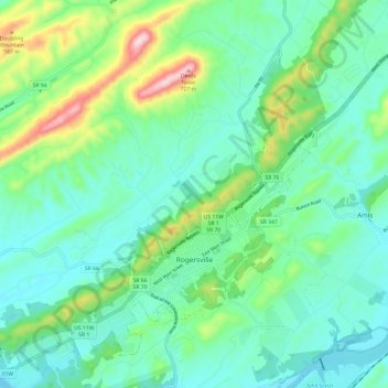
Name: Rogersville topographic map, elevation, terrain.
Average elevation: 416 m
Minimum elevation: 321 m
Maximum elevation: 716 m
Make a donation
Gear up for your next adventure:
As an Amazon Associate, this site earns from qualifying purchases at no extra cost to you.
Other topographic maps
Click on a map to view its topography, its elevation and its terrain.
Make a donation
Gear up for your next adventure:
As an Amazon Associate, this site earns from qualifying purchases at no extra cost to you.
Make a donation
Gear up for your next adventure:
As an Amazon Associate, this site earns from qualifying purchases at no extra cost to you.