
Ramstein topographic map
Interactive map
Click on the map to display elevation.
About this map
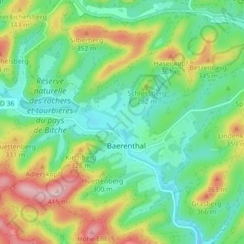
Name: Ramstein topographic map, elevation, terrain.
Average elevation: 265 m
Minimum elevation: 194 m
Maximum elevation: 402 m
Other topographic maps
Click on a map to view its topography, its elevation and its terrain.
Untermuehlthal
France > Grand Est > Moselle > Baerenthal
Untermuehlthal, Baerenthal, Sarreguemines, Moselle, Grand Est, France métropolitaine, 57230, France
Average elevation: 290 m