Geolocate

Tellaro topographic map

Click on the map to display elevation.

About this map

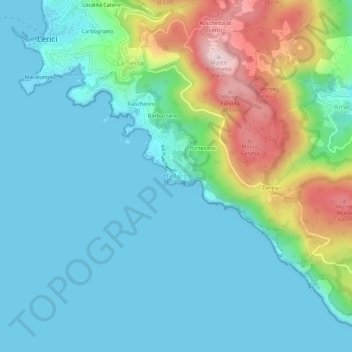
Name: Tellaro topographic map, elevation, terrain.

Location: Tellaro, Lerici, La Spezia, Liguria, 19032, Italy (44.03802 9.91037 44.07802 9.95037)

Average elevation: 94 m

Minimum elevation: 0 m

Maximum elevation: 410 m

Gear up for your next adventure:

📟Satellite Messengers - Two-way satellite communication to stay in touch beyond the cellular grid
🦟Insect Repellent - Protection against insects
🧊Insulated Cooler Bags - Keep food fresh for day trips to remote geographic sites
📸Action Cameras - Record your journey across interesting topographic features in 4K
📕Hiking Guide Books - Guides for hiking trails

As an Amazon Associate, this site earns from qualifying purchases at no extra cost to you.