
Make a donation
Gear up for your next adventure:
As an Amazon Associate, this site earns from qualifying purchases at no extra cost to you.
Elgin topographic map
Click on the map to display elevation.
Make a donation
Gear up for your next adventure:
As an Amazon Associate, this site earns from qualifying purchases at no extra cost to you.
About this map
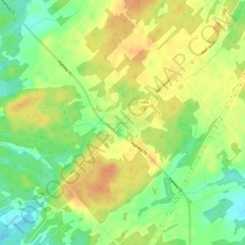
Name: Elgin topographic map, elevation, terrain.
Average elevation: 138 m
Minimum elevation: 117 m
Maximum elevation: 155 m
Make a donation
Gear up for your next adventure:
As an Amazon Associate, this site earns from qualifying purchases at no extra cost to you.
Other topographic maps
Click on a map to view its topography, its elevation and its terrain.
Whitefish Lake
Canada > Ontario > Leeds and Grenville Counties > Rideau Lakes
Average elevation: 122 m
Little Crosby Lake
Canada > Ontario > Leeds and Grenville Counties > Rideau Lakes
Average elevation: 166 m
Upper Rideau Lake
Canada > Ontario > Leeds and Grenville Counties > Rideau Lakes > Newboro
Average elevation: 148 m
Make a donation
Gear up for your next adventure:
As an Amazon Associate, this site earns from qualifying purchases at no extra cost to you.
Spectacle Lake
Canada > Ontario > Leeds and Grenville Counties > Rideau Lakes
Average elevation: 189 m