
Make a donation
Gear up for your next adventure:
As an Amazon Associate, this site earns from qualifying purchases at no extra cost to you.
Nesslau topographic map
Click on the map to display elevation.
Make a donation
Gear up for your next adventure:
As an Amazon Associate, this site earns from qualifying purchases at no extra cost to you.
About this map
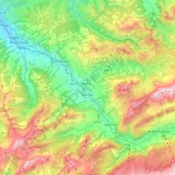
Name: Nesslau topographic map, elevation, terrain.
Location: Nesslau, Wahlkreis Toggenburg, St. Gallen, Switzerland (47.17728 9.12282 47.27889 9.32380)
Average elevation: 1,163 m
Minimum elevation: 620 m
Maximum elevation: 1,964 m
Make a donation
Gear up for your next adventure:
As an Amazon Associate, this site earns from qualifying purchases at no extra cost to you.
Other topographic maps
Click on a map to view its topography, its elevation and its terrain.
Wildhaus
Switzerland > St. Gallen > Wahlkreis Toggenburg > Wildhaus-Alt St. Johann
Average elevation: 1,244 m
Riet
Switzerland > St. Gallen > Wahlkreis Toggenburg > Bütschwil-Ganterschwil > Bütschwil
Average elevation: 687 m
Make a donation
Gear up for your next adventure:
As an Amazon Associate, this site earns from qualifying purchases at no extra cost to you.