
Puerto Rico topographic map
Interactive map
Click on the map to display elevation.
About this map
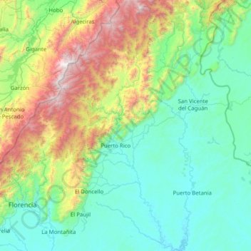
Name: Puerto Rico topographic map, elevation, terrain.
Location: Puerto Rico, Caquetá, Amazonia, Colombia (1.38758 -75.34858 2.62838 -74.78266)
Average elevation: 846 m
Minimum elevation: 207 m
Maximum elevation: 3,444 m
The island is mostly mountainous with large coastal areas in the north and south. The main mountain range is called "La Cordillera Central" (The Central Range). The highest elevation in Puerto Rico, Cerro de Punta 4,390 feet (1,340 m), is located in this range.
Other topographic maps
Click on a map to view its topography, its elevation and its terrain.
Belén de los Andaquíes
Belén de los Andaquíes, Caquetá, Colombia
Average elevation: 797 m
Chiribiquete (Macizo Central)
Chiribiquete (Macizo Central), Solano, Caquetá, Colombia
Average elevation: 290 m
burnt forest?
burnt forest?, Solano, Caquetá, Colombia
Average elevation: 188 m
Puerto Gaitan
Colombia > Caquetá > Puerto Gaitan
Puerto Gaitan, La Montañita, Caquetá, Colombia
Average elevation: 249 m
La Virgina
Colombia > Caquetá > La Virgina
La Virgina, Morelia, Caquetá, Colombia
Average elevation: 239 m