Geolocate

Camarin topographic map

Click on the map to display elevation.

About this map
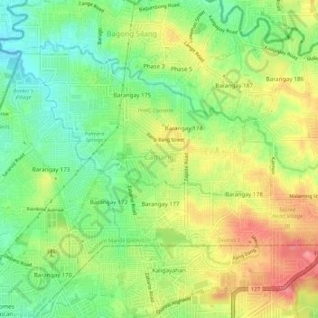
Name: Camarin topographic map, elevation, terrain.

Location: Camarin, District 1, Caloocan, Northern Manila District, Metro Manila, Philippines (14.73806 121.02676 14.77327 121.07793)

Average elevation: 68 m

Minimum elevation: 30 m

Maximum elevation: 113 m

Other topographic maps

Click on a map to view its topography, its elevation and its terrain.

Caybiga

Philippines > Caloocan

Average elevation: 38 m

Caybiga

Philippines > Caloocan

Average elevation: 38 m

Caybiga

Philippines > Caloocan

Average elevation: 38 m

Gear up for your next adventure:

🧢Wide Brim Sun Hats - Maximum coverage for the face and neck while out in the open
🎨Portable Watercolor Kits - Paint the landscapes and topographic views you discover
🧊Insulated Cooler Bags - Keep food fresh for day trips to remote geographic sites
🪢Paracord - Multi-purpose survival cord
🧼Clip-on Hand Sanitizer - Maintain hygiene when water for washing is scarce

As an Amazon Associate, this site earns from qualifying purchases at no extra cost to you.