
Make a donation
Gear up for your next adventure:
As an Amazon Associate, this site earns from qualifying purchases at no extra cost to you.
Cambria topographic map
Click on the map to display elevation.
Make a donation
Gear up for your next adventure:
As an Amazon Associate, this site earns from qualifying purchases at no extra cost to you.
Cambria
Originally an American settlement called Slab Town, the town later known as Cambria was centered at the Leffingwell cove of today's northern Moonstone Beach, which beach also featured a wharf. Because lumber production, ranching activities and mercury mining increased in the area, the village adopted the more dignified name of Cambria. Locals seem to agree that the name was contributed by a local surveyor from Cambria County, Pennsylvania, because the local topography and flora reminded him of that place. However this differs from Onomastic data published in several other sources. A 1960 study of California place names, often contemporarily quoted elsewhere states "A Welshman named Llewellyn dubbed his shop 'The Cambria Carpenter Shop,' and in 1869, the good folks adopted it as the official name." Forty-three years prior to that, the History of San Luis Obispo County and environs contains a similar account.
Make a donation
Gear up for your next adventure:
As an Amazon Associate, this site earns from qualifying purchases at no extra cost to you.
About this map
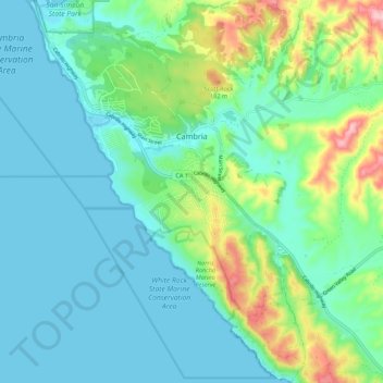
Name: Cambria topographic map, elevation, terrain.
Location: Cambria, San Luis Obispo County, California, United States (35.50730 -121.12736 35.59544 -121.04896)
Average elevation: 58 m
Minimum elevation: 0 m
Maximum elevation: 257 m
Make a donation
Gear up for your next adventure:
As an Amazon Associate, this site earns from qualifying purchases at no extra cost to you.
Other topographic maps
Click on a map to view its topography, its elevation and its terrain.
Make a donation
Gear up for your next adventure:
As an Amazon Associate, this site earns from qualifying purchases at no extra cost to you.
Make a donation
Gear up for your next adventure:
As an Amazon Associate, this site earns from qualifying purchases at no extra cost to you.
Make a donation
Gear up for your next adventure:
As an Amazon Associate, this site earns from qualifying purchases at no extra cost to you.
Pike Place
United States > California > San Luis Obispo County > Oceano > Halcyon
Average elevation: 25 m
Avila Beach
United States > California > San Luis Obispo County
The beach is less than 0.5 miles (0.8 km) long and sheltered in San Luis Bay, which is formed by Point San Luis on the west and Fossil Point on the east. Avila Beach faces south and the 600 foot elevation of Point San Luis breaks the prevailing northwesterly winds. It is therefore usually warmer than the other…
Average elevation: 46 m
Guadalupe-Nipomo Dunes National Wildlife Refuge
United States > California > San Luis Obispo County
Average elevation: 21 m
Make a donation
Gear up for your next adventure:
As an Amazon Associate, this site earns from qualifying purchases at no extra cost to you.
Make a donation
Gear up for your next adventure:
As an Amazon Associate, this site earns from qualifying purchases at no extra cost to you.
Make a donation
Gear up for your next adventure:
As an Amazon Associate, this site earns from qualifying purchases at no extra cost to you.
Make a donation
Gear up for your next adventure:
As an Amazon Associate, this site earns from qualifying purchases at no extra cost to you.
Make a donation
Gear up for your next adventure:
As an Amazon Associate, this site earns from qualifying purchases at no extra cost to you.
Arroyo Grande
United States > California > San Luis Obispo County > Arroyo Grande > Arroyo Grande
Average elevation: 56 m
Make a donation
Gear up for your next adventure:
As an Amazon Associate, this site earns from qualifying purchases at no extra cost to you.