
Make a donation
Gear up for your next adventure:
As an Amazon Associate, this site earns from qualifying purchases at no extra cost to you.
Heek topographic map
Click on the map to display elevation.
Make a donation
Gear up for your next adventure:
As an Amazon Associate, this site earns from qualifying purchases at no extra cost to you.
About this map
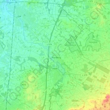
Name: Heek topographic map, elevation, terrain.
Location: Heek, Kreis Borken, Nordrhein-Westfalen, 48619, Deutschland (52.08000 7.01276 52.19690 7.17437)
Average elevation: 53 m
Minimum elevation: 38 m
Maximum elevation: 93 m
Make a donation
Gear up for your next adventure:
As an Amazon Associate, this site earns from qualifying purchases at no extra cost to you.
Other topographic maps
Click on a map to view its topography, its elevation and its terrain.
Isselburg
Deutschland > Nordrhein-Westfalen > Kreis Borken > Isselburg > Isselburg
Average elevation: 19 m
Make a donation
Gear up for your next adventure:
As an Amazon Associate, this site earns from qualifying purchases at no extra cost to you.
Make a donation
Gear up for your next adventure:
As an Amazon Associate, this site earns from qualifying purchases at no extra cost to you.
Vogelhorst
Deutschland > Nordrhein-Westfalen > Kreis Borken > Isselburg > Klein Schlüsen
Average elevation: 18 m
Springerlei
Deutschland > Nordrhein-Westfalen > Kreis Borken > Isselburg > Bruchschläge
Average elevation: 19 m
Make a donation
Gear up for your next adventure:
As an Amazon Associate, this site earns from qualifying purchases at no extra cost to you.
Ramsdorf
Deutschland > Nordrhein-Westfalen > Kreis Borken
Ramsdorf ist ein Ortsteil der Stadt Velen im Kreis Borken im westlichen Münsterland (Nordrhein-Westfalen). Er liegt nordwestlich des Höhenzugs Die Berge (Borken-Ramsdorfer Berge) an der Bocholter Aa, die nördlich von Velen entspringt. Bis 1975 war Ramsdorf eine eigenständige Gemeinde, die zeitweise als…
Average elevation: 56 m
Knüverdarp
Deutschland > Nordrhein-Westfalen > Kreis Borken > Velen > Knüverdarp
Average elevation: 65 m
Make a donation
Gear up for your next adventure:
As an Amazon Associate, this site earns from qualifying purchases at no extra cost to you.
Liedern
Deutschland > Nordrhein-Westfalen > Kreis Borken > Bocholt > Liedern
Liedern liegt am westlichen Rand des Bocholter Stadtgebiets und war ursprünglich eine rein landwirtschaftlich geprägte Streusiedlung. Im Verlauf des 20. Jahrhunderts hat sich an der Landstraße nach Werth in Höhe Anholter Postweg ein Siedlungskern gebildet. Die ehemalige Gemeinde Liedern besaß eine Fläche…
Average elevation: 21 m
Wenningfeld
Deutschland > Nordrhein-Westfalen > Kreis Borken > Stadtlohn > Wenningfeld
Average elevation: 50 m
Finkenbusch
Deutschland > Nordrhein-Westfalen > Kreis Borken > Isselburg > Bruchschläge
Average elevation: 19 m
Make a donation
Gear up for your next adventure:
As an Amazon Associate, this site earns from qualifying purchases at no extra cost to you.
Wasserburg Anholt
Deutschland > Nordrhein-Westfalen > Kreis Borken > Isselburg
Average elevation: 18 m