
Thank you for supporting this site ❤️
Make a donation
Make a donation
Gear up for your next adventure:
As an Amazon Associate, this site earns from qualifying purchases at no extra cost to you.
Terracotta topographic map
Click on the map to display elevation.
Thank you for supporting this site ❤️
Make a donation
Make a donation
Gear up for your next adventure:
As an Amazon Associate, this site earns from qualifying purchases at no extra cost to you.
About this map
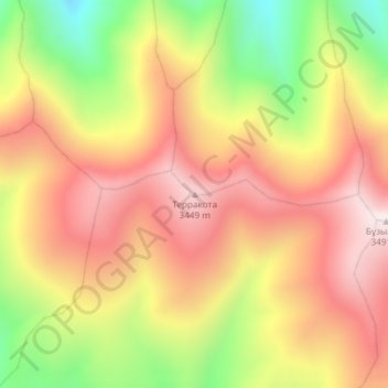
Name: Terracotta topographic map, elevation, terrain.
Location: Terracotta, Enbekshikazakh District, Almaty Region, Kazakhstan (43.29831 77.89695 43.29841 77.89705)
Average elevation: 3,177 m
Minimum elevation: 2,768 m
Maximum elevation: 3,484 m
Thank you for supporting this site ❤️
Make a donation
Make a donation
Gear up for your next adventure:
As an Amazon Associate, this site earns from qualifying purchases at no extra cost to you.