
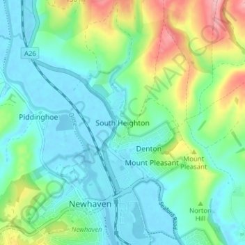
South Heighton topographic map
Interactive map
Click on the map to display elevation.
About this map
Name: South Heighton topographic map, elevation, terrain.
Average elevation: 37 m
Minimum elevation: -3 m
Maximum elevation: 140 m
Other topographic maps
Click on a map to view its topography, its elevation and its terrain.
Peacehaven
United Kingdom > England > East Sussex > Lewes
Peacehaven, Lewes, East Sussex, England, United Kingdom
Average elevation: 40 m
Lewes
United Kingdom > England > East Sussex > Lewes
Lewes, East Sussex, England, United Kingdom
Average elevation: 40 m
Plumpton
United Kingdom > England > East Sussex > Lewes
Plumpton, Lewes, East Sussex, South East England, England, United Kingdom
Average elevation: 71 m