
Barrow County topographic map
Interactive map
Click on the map to display elevation.
About this map
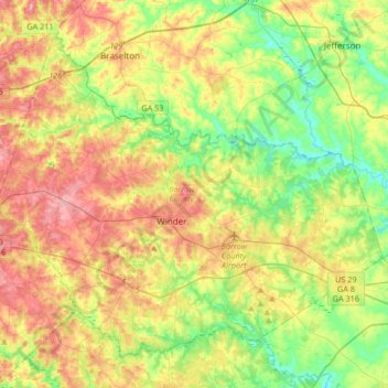
Name: Barrow County topographic map, elevation, terrain.
Location: Barrow County, Georgia, Verenigde Staten (33.89457 -83.86912 34.12752 -83.53747)
Average elevation: 261 m
Minimum elevation: 203 m
Maximum elevation: 336 m
Other topographic maps
Click on a map to view its topography, its elevation and its terrain.
Blakely
Verenigde Staten > Georgia > Early County
Blakely, Early County, Georgia, 39823, Verenigde Staten
Average elevation: 78 m
Columbus
Verenigde Staten > Georgia > Muscogee County
Columbus, Muscogee County, Georgia, Verenigde Staten
Average elevation: 130 m
Duluth
Verenigde Staten > Georgia > Gwinnett County
Duluth, Gwinnett County, Georgia, Verenigde Staten
Average elevation: 305 m
Helen
Verenigde Staten > Georgia > White County
Helen, White County, Georgia, 30545, Verenigde Staten
Average elevation: 488 m
Floyd County
Verenigde Staten > Georgia > Floyd County
Floyd County, Georgia, Verenigde Staten
Average elevation: 238 m
Gwinnett County
Verenigde Staten > Georgia > Gwinnett County
Gwinnett County, Georgia, Verenigde Staten
Average elevation: 302 m
Atlanta
Verenigde Staten > Georgia > Fulton County
Atlanta, Fulton County, Georgia, Verenigde Staten
Average elevation: 284 m
Kennesaw
Verenigde Staten > Georgia > Kennesaw
Kennesaw, Cobb County, Georgia, Verenigde Staten
Average elevation: 317 m
Millen
Verenigde Staten > Georgia > Jenkins County
Millen, Jenkins County, Georgia, Verenigde Staten
Average elevation: 51 m
Macon
Verenigde Staten > Georgia > Bibb County
Macon, Bibb County, Georgia, Verenigde Staten
Average elevation: 127 m