
Aynor topographic map
Click on the map to display elevation.
About this map
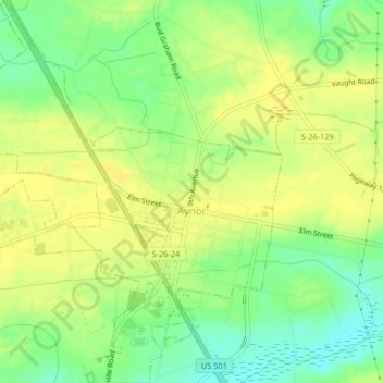
Name: Aynor topographic map, elevation, terrain.
Location: Aynor, Horry County, South Carolina, United States (33.98450 -79.22947 34.01864 -79.18970)
Average elevation: 27 m
Minimum elevation: 14 m
Maximum elevation: 34 m
Other topographic maps
Click on a map to view its topography, its elevation and its terrain.
Windy Hill Beach
United States > South Carolina > Horry County > North Myrtle Beach
Average elevation: 2 m
Cherry Grove Beach
United States > South Carolina > Horry County > North Myrtle Beach
Average elevation: 1 m
Market Common District
United States > South Carolina > Horry County > Myrtle Beach
Average elevation: 5 m
Ingram Beach
United States > South Carolina > Horry County > North Myrtle Beach > Ocean Drive Beach
Average elevation: 2 m
Barefoot Resort
United States > South Carolina > Horry County > North Myrtle Beach
Average elevation: 4 m
Windy Hill Beach
United States > South Carolina > Horry County > North Myrtle Beach
Average elevation: 2 m
Cherry Grove Beach
United States > South Carolina > Horry County > North Myrtle Beach
Average elevation: 1 m
Seabrook Plantation
United States > South Carolina > Horry County > North Myrtle Beach
Average elevation: 3 m
Market Common District
United States > South Carolina > Horry County > Myrtle Beach
Average elevation: 5 m