Geolocate

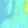
Cabadiangan topographic map

Click on the map to display elevation.

About this map

Name: Cabadiangan topographic map, elevation, terrain.

Location: Cabadiangan, Himamaylan, Negros Occidental, Negros Island Region, 6107, Philippines (10.12042 122.92699 10.16042 122.96699)

Average elevation: 60 m

Minimum elevation: 27 m

Maximum elevation: 138 m

Other topographic maps

Click on a map to view its topography, its elevation and its terrain.
Gear up for your next adventure:

📖Australian Bush Survival Books - Local knowledge on finding water and surviving the outback
🪢550 Survival Paracord - Versatile cordage for gear repair and emergency lashing
🧊Insulated Cooler Bags - Keep food fresh for day trips to remote geographic sites
☀️Portable Solar Chargers - High-efficiency panels to hang on your backpack while walking
🔋Rechargeable Batteries - Eco-friendly power for high-drain GPS units and flashlights

As an Amazon Associate, this site earns from qualifying purchases at no extra cost to you.