Geolocate

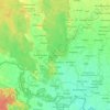
Dhangadhi topographic map

Click on the map to display elevation.

About this map

Name: Dhangadhi topographic map, elevation, terrain.

Location: Dhangadhi, Kailali, Sudurpashchim Province, Nepal (28.54330 80.40702 28.86330 80.72702)

Average elevation: 193 m

Minimum elevation: 156 m

Maximum elevation: 951 m

Other topographic maps

Click on a map to view its topography, its elevation and its terrain.

Chure

Nepal > Sudurpashchim Province > Kailali

Average elevation: 939 m

Bhajani

Nepal > Sudurpashchim Province > Kailali

Average elevation: 152 m

Bhajani

Nepal > Sudurpashchim Province > Kailali

Average elevation: 152 m

Gear up for your next adventure:

☀️Portable Solar Chargers - High-efficiency panels to hang on your backpack while walking
🕯️Emergency Whistles - Safety whistles for hiking
📍Handheld GPS - GPS devices for hiking and navigation
📖Australian Bush Survival Books - Local knowledge on finding water and surviving the outback
🛌Sleeping Mats - Insulated mats for camping comfort

As an Amazon Associate, this site earns from qualifying purchases at no extra cost to you.