
Inskip Point topographic map
Interactive map
Click on the map to display elevation.
About this map
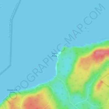
Name: Inskip Point topographic map, elevation, terrain.
Average elevation: 14 m
Minimum elevation: 0 m
Maximum elevation: 81 m
Other topographic maps
Click on a map to view its topography, its elevation and its terrain.
Middle Hill
Canada > British Columbia > North Coast Regional District > Area D (Graham Island)
Middle Hill, Area D (Graham Island), North Coast Regional District, British Columbia, Canada
Average elevation: 248 m