
玛曲县 topographic map
Interactive map
Click on the map to display elevation.
About this map
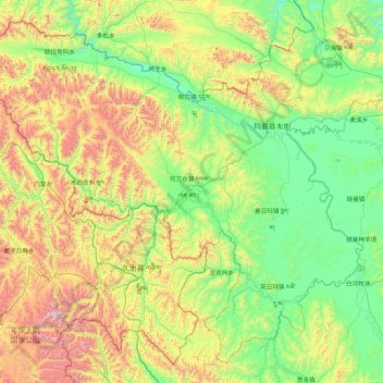
Name: 玛曲县 topographic map, elevation, terrain.
Location: 玛曲县, 甘南藏族自治州, Gansu, China (33.10520 100.76286 34.38453 102.48214)
Average elevation: 3,812 m
Minimum elevation: 3,305 m
Maximum elevation: 5,295 m
Other topographic maps
Click on a map to view its topography, its elevation and its terrain.
日宗
China > Gansu > ཐེ་བོ་རྫོང་ 迭部县
日宗, ཐེ་བོ་རྫོང་ 迭部县, 甘南藏族自治州, Gansu, China
Average elevation: 3,252 m