
Mount Olive topographic map
Interactive map
Click on the map to display elevation.
About this map
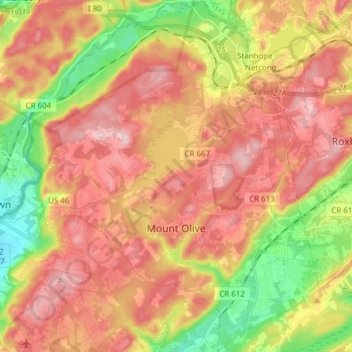
Name: Mount Olive topographic map, elevation, terrain.
Location: Mount Olive, Morris County, New Jersey, United States (40.80552 -74.82171 40.92084 -74.68118)
Average elevation: 280 m
Minimum elevation: 154 m
Maximum elevation: 380 m
Other topographic maps
Click on a map to view its topography, its elevation and its terrain.
Schooleys Mountain
United States > New Jersey > Morris County > Washington Township
Average elevation: 293 m
Calais Crossroads
United States > New Jersey > Morris County > Randolph Township
Average elevation: 284 m
Washington Valley
United States > New Jersey > Morris County > Morris Township
Average elevation: 152 m
Lake Hiawatha
United States > New Jersey > Morris County > Parsippany-Troy Hills
Average elevation: 76 m
Lower Montville
United States > New Jersey > Morris County > Montville Township
Average elevation: 84 m
Mooney Mountain Park
United States > New Jersey > Morris County > Roxbury Township
Average elevation: 326 m
Roxbury Township
United States > New Jersey > Morris County > Roxbury Township
Average elevation: 264 m
Rockaway Valley
United States > New Jersey > Morris County > Boonton Township
Average elevation: 181 m
Beach Glen
United States > New Jersey > Morris County > Rockaway Township > Beach Glen
Average elevation: 209 m
Floral Hill
United States > New Jersey > Morris County > Chatham Township > Floral Hill
Average elevation: 90 m