Geolocate

Fackler topographic map

Click on the map to display elevation.

About this map

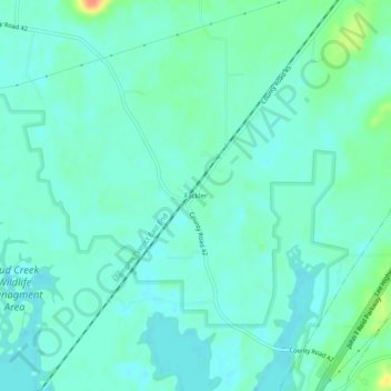
Name: Fackler topographic map, elevation, terrain.

Location: Fackler, Jackson County, Alabama, United States (34.77258 -85.92998 34.81258 -85.88998)

Average elevation: 188 m

Minimum elevation: 177 m

Maximum elevation: 225 m

Other topographic maps

Click on a map to view its topography, its elevation and its terrain.

Langston

United States > Alabama > Jackson County

Average elevation: 243 m

Paint Rock

United States > Alabama > Jackson County

Average elevation: 247 m

Pleasant Groves

United States > Alabama > Jackson County

Average elevation: 331 m

Skyline

United States > Alabama > Jackson County

Average elevation: 389 m

Hytop

United States > Alabama > Jackson County

Average elevation: 413 m

Dutton

United States > Alabama > Jackson County

Average elevation: 410 m

Scottsboro

United States > Alabama > Jackson County

Average elevation: 235 m

Stevenson

United States > Alabama > Jackson County

Average elevation: 247 m

Paint Rock

United States > Alabama > Jackson County

Average elevation: 249 m

Pisgah

United States > Alabama > Jackson County > Pisgah

Average elevation: 419 m

Gear up for your next adventure:

🔥Ferrocerium Rod Fire Starters - Reliable fire lighting in wet or windy conditions without matches
🖼️Scratch-off Australia Map - Track the regions and peaks you have explored geographically
🧼Biodegradable Soap - Eco-friendly outdoor soap
🎒Daypacks - Compact backpacks for short hikes
👕UPF 50+ Sun Shirts - Essential protection against the harsh Australian sun during field work

As an Amazon Associate, this site earns from qualifying purchases at no extra cost to you.