
Make a donation
Gear up for your next adventure:
As an Amazon Associate, this site earns from qualifying purchases at no extra cost to you.
Desert topographic map
Click on the map to display elevation.
Make a donation
Gear up for your next adventure:
As an Amazon Associate, this site earns from qualifying purchases at no extra cost to you.
About this map
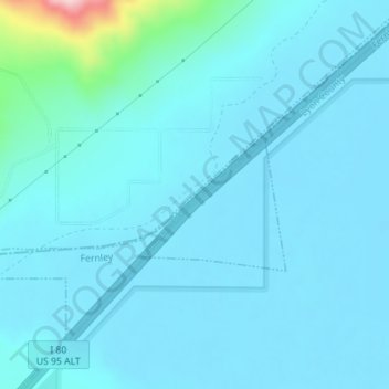
Name: Desert topographic map, elevation, terrain.
Location: Desert, Churchill County, Nevada, United States (39.64771 -119.16806 39.66771 -119.14806)
Average elevation: 1,247 m
Minimum elevation: 1,221 m
Maximum elevation: 1,513 m
Make a donation
Gear up for your next adventure:
As an Amazon Associate, this site earns from qualifying purchases at no extra cost to you.
Other topographic maps
Click on a map to view its topography, its elevation and its terrain.
Fallon
United States > Nevada > Churchill County
Fallon experiences a cold desert climate, with hot summers and cold winters. Due to Fallon's elevation and aridity, the diurnal temperature variation is quite substantial, especially in the summer months. Fallon's climate is quite dry, due to its location in the rain shadow of the Sierra Nevada. Summer days…
Average elevation: 1,210 m