
Dunai topographic map
Interactive map
Click on the map to display elevation.
About this map
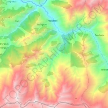
Name: Dunai topographic map, elevation, terrain.
Location: Dunai, Thuli Bheri, डोल्पा, Karnali, Népal (28.82388 82.81762 28.98172 82.95447)
Average elevation: 3,446 m
Minimum elevation: 2,034 m
Maximum elevation: 5,250 m
Other topographic maps
Click on a map to view its topography, its elevation and its terrain.
Chharka Bhot
Chharka Bhot, Chharka, Chharka Tangsong, डोल्पा, Karnali, Népal
Average elevation: 4,652 m