
Make a donation
Gear up for your next adventure:
As an Amazon Associate, this site earns from qualifying purchases at no extra cost to you.
Bouzina topographic map
Click on the map to display elevation.
Make a donation
Gear up for your next adventure:
As an Amazon Associate, this site earns from qualifying purchases at no extra cost to you.
Bouzina
Bouzina is located 200 km inland from the southern coast of the Mediterranean Sea, in a mountainous area with an average altitude of 929 meters. It is surrounded by 8 other similar towns within a 20 km radius - Tenient el Abed (7.8 km), Chir (8 km), Ben Foudhala el Hakania (11.3 km), Oued Taga (11.5 km), Meena (15 km), Tighergar (19.1 km), Tighanimine (19.4 km) and Maafa (19.8 km).
Make a donation
Gear up for your next adventure:
As an Amazon Associate, this site earns from qualifying purchases at no extra cost to you.
About this map
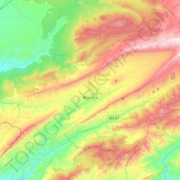
Name: Bouzina topographic map, elevation, terrain.
Location: Bouzina, Bouzina district, Batna, 05041, Algeria (35.19781 5.94791 35.35455 6.29155)
Average elevation: 1,363 m
Minimum elevation: 780 m
Maximum elevation: 2,187 m
Make a donation
Gear up for your next adventure:
As an Amazon Associate, this site earns from qualifying purchases at no extra cost to you.