
Make a donation
Gear up for your next adventure:
As an Amazon Associate, this site earns from qualifying purchases at no extra cost to you.
Madagascar topographic map
Click on the map to display elevation.
Make a donation
Gear up for your next adventure:
As an Amazon Associate, this site earns from qualifying purchases at no extra cost to you.
Madagascar
Madagascar can be divided into five general geographical regions: the east coast, the Tsaratanana Massif, the Central Highlands, the west coast, and the southwest. The highest elevations parallel the east coast. The total size is 587,040 square kilometres (226,660 sq mi), which makes it the world's second largest island country.
Make a donation
Gear up for your next adventure:
As an Amazon Associate, this site earns from qualifying purchases at no extra cost to you.
About this map
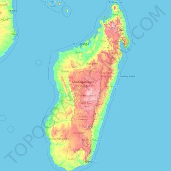
Name: Madagascar topographic map, elevation, terrain.
Location: Madagascar, Province d’Antananarivo, Madagascar (-25.60614 43.22023 -11.95203 50.48606)
Average elevation: 144 m
Minimum elevation: -1 m
Maximum elevation: 2,699 m
Make a donation
Gear up for your next adventure:
As an Amazon Associate, this site earns from qualifying purchases at no extra cost to you.