
Parchim topographic map
Interactive map
Click on the map to display elevation.
About this map
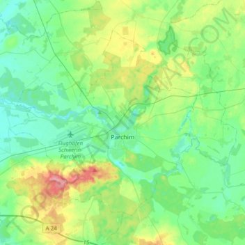
Name: Parchim topographic map, elevation, terrain.
Location: Parchim, Ludwigslust-Parchim, Mecklenburg-Vorpommern, Germany (53.36851 11.63883 53.50405 11.93907)
Average elevation: 61 m
Minimum elevation: 36 m
Maximum elevation: 129 m
Other topographic maps
Click on a map to view its topography, its elevation and its terrain.
Vielank
Germany > Mecklenburg-Vorpommern > Ludwigslust-Parchim
Vielank, Dömitz-Malliß, Ludwigslust-Parchim, Mecklenburg-Vorpommern, Germany
Average elevation: 20 m
Valluhn
Germany > Mecklenburg-Vorpommern > Ludwigslust-Parchim > Lüttow-Valluhn
Valluhn, Lüttow-Valluhn, Zarrentin, Ludwigslust-Parchim, Mecklenburg-Vorpommern, Germany
Average elevation: 32 m
Below
Germany > Mecklenburg-Vorpommern > Ludwigslust-Parchim > Below
Below, Techentin, Goldberg-Mildenitz, Ludwigslust-Parchim, Mecklenburg-Vorpommern, 19399, Germany
Average elevation: 66 m
Ludwigslust
Germany > Mecklenburg-Vorpommern > Ludwigslust-Parchim
Ludwigslust, Ludwigslust-Parchim, Mecklenburg-Vorpommern, 19288, Germany
Average elevation: 32 m
Brüel
Germany > Mecklenburg-Vorpommern > Ludwigslust-Parchim
Brüel, Sternberger Seenlandschaft, Ludwigslust-Parchim, Mecklenburg-Vorpommern, 19412, Germany
Average elevation: 32 m
Warsow
Germany > Mecklenburg-Vorpommern > Ludwigslust-Parchim
Warsow, Stralendorf, Ludwigslust-Parchim, Mecklenburg-Vorpommern, Germany
Average elevation: 45 m