
Make a donation
Gear up for your next adventure:
As an Amazon Associate, this site earns from qualifying purchases at no extra cost to you.
Killian topographic map
Click on the map to display elevation.
Make a donation
Gear up for your next adventure:
As an Amazon Associate, this site earns from qualifying purchases at no extra cost to you.
About this map
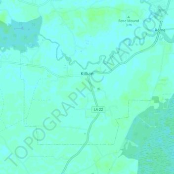
Name: Killian topographic map, elevation, terrain.
Location: Killian, Livingston Parish, Louisiana, United States (30.32900 -90.61862 30.37737 -90.53385)
Average elevation: 4 m
Minimum elevation: 2 m
Maximum elevation: 9 m
Make a donation
Gear up for your next adventure:
As an Amazon Associate, this site earns from qualifying purchases at no extra cost to you.
Other topographic maps
Click on a map to view its topography, its elevation and its terrain.
Make a donation
Gear up for your next adventure:
As an Amazon Associate, this site earns from qualifying purchases at no extra cost to you.
Magnolia Landing
United States > Louisiana > Livingston Parish > Magnolia Landing
Average elevation: 5 m