
Make a donation
Gear up for your next adventure:
As an Amazon Associate, this site earns from qualifying purchases at no extra cost to you.
Blagoevgrad topographic map
Click on the map to display elevation.
Make a donation
Gear up for your next adventure:
As an Amazon Associate, this site earns from qualifying purchases at no extra cost to you.
About this map
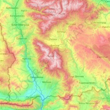
Name: Blagoevgrad topographic map, elevation, terrain.
Location: Blagoevgrad, Bulgaria (41.31662 22.86349 42.18366 24.11510)
Average elevation: 1,084 m
Minimum elevation: 61 m
Maximum elevation: 2,883 m
Make a donation
Gear up for your next adventure:
As an Amazon Associate, this site earns from qualifying purchases at no extra cost to you.
Other topographic maps
Click on a map to view its topography, its elevation and its terrain.
Make a donation
Gear up for your next adventure:
As an Amazon Associate, this site earns from qualifying purchases at no extra cost to you.
Make a donation
Gear up for your next adventure:
As an Amazon Associate, this site earns from qualifying purchases at no extra cost to you.
Make a donation
Gear up for your next adventure:
As an Amazon Associate, this site earns from qualifying purchases at no extra cost to you.
Bansko
Bansko (Bulgarian: Банско [ˈbansko]) is a town in southwestern Bulgaria, located at the foot of the Pirin Mountains at an elevation of 925 above sea level. It is a ski resort.
Average elevation: 1,034 m
Make a donation
Gear up for your next adventure:
As an Amazon Associate, this site earns from qualifying purchases at no extra cost to you.