Geolocate

Binduyan topographic map

Click on the map to display elevation.

About this map
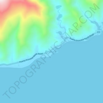
Name: Binduyan topographic map, elevation, terrain.

Location: Binduyan, Puerto Princesa, Mimaropa, Philippines (9.99469 119.05199 10.03469 119.09199)

Average elevation: 89 m

Minimum elevation: -1 m

Maximum elevation: 629 m

Other topographic maps

Click on a map to view its topography, its elevation and its terrain.

Baywalk Park

Philippines > Puerto Princesa

Average elevation: 6 m

Bacungan River

Philippines > Puerto Princesa

Average elevation: 123 m

Irawan River

Philippines > Puerto Princesa

Average elevation: 120 m

Tagkawayan Beach

Philippines > Puerto Princesa

Average elevation: 48 m

Sabang River

Philippines > Puerto Princesa

Average elevation: 39 m

Manors Verdant

Philippines > Puerto Princesa

Average elevation: 5 m

Gear up for your next adventure:

🎨Portable Watercolor Kits - Paint the landscapes and topographic views you discover
🧥Down Jackets - Insulated jackets for cold weather
🍶Collapsible Water Bottles - Save space in your pack as you consume your water supply
📟Satellite Messengers - Two-way satellite communication to stay in touch beyond the cellular grid
🍳Camping Cookware - Cookware sets for outdoor meals

As an Amazon Associate, this site earns from qualifying purchases at no extra cost to you.