
District Nord topographic map
Interactive map
Click on the map to display elevation.
About this map
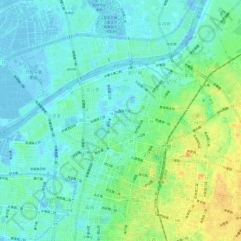
Name: District Nord topographic map, elevation, terrain.
Location: District Nord, Tainan, 704, Taïwan (22.99730 120.17317 23.02295 120.23303)
Average elevation: 11 m
Minimum elevation: -21 m
Maximum elevation: 37 m
Other topographic maps
Click on a map to view its topography, its elevation and its terrain.
District de Yongkang
Taïwan > Tainan > District de Yongkang
District de Yongkang, Tainan, 710, Taïwan
Average elevation: 13 m