
Make a donation
Gear up for your next adventure:
As an Amazon Associate, this site earns from qualifying purchases at no extra cost to you.
Cap-Chat topographic map
Click on the map to display elevation.
Make a donation
Gear up for your next adventure:
As an Amazon Associate, this site earns from qualifying purchases at no extra cost to you.
About this map
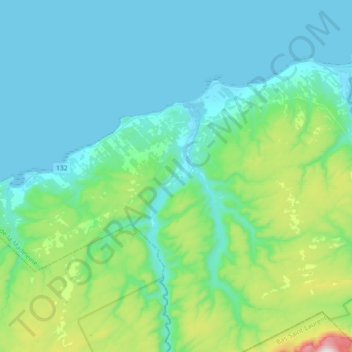
Name: Cap-Chat topographic map, elevation, terrain.
Average elevation: 166 m
Minimum elevation: -4 m
Maximum elevation: 1,023 m
Make a donation
Gear up for your next adventure:
As an Amazon Associate, this site earns from qualifying purchases at no extra cost to you.
Other topographic maps
Click on a map to view its topography, its elevation and its terrain.
Madeleine-Centre
Canada > Quebec > La Haute-Gaspésie > Sainte-Madeleine-de-la-Rivière-Madeleine
Average elevation: 72 m
Rivière-la-Madeleine
Canada > Quebec > La Haute-Gaspésie > Sainte-Madeleine-de-la-Rivière-Madeleine
Average elevation: 46 m
Make a donation
Gear up for your next adventure:
As an Amazon Associate, this site earns from qualifying purchases at no extra cost to you.
Notre Dame Mountains
Canada > Quebec > La Haute-Gaspésie > Mont-Albert
The Chic-Choc Mountains are one of the primary subranges of the Notre Dame Mountains. They are located in the northeastern part of the Gaspé Peninsula and are home to the tallest mountain in the range, Mont Jacques-Cartier, with an elevation of 1,268 m (4,160 ft). The other major subsection of the Notre Dame…
Average elevation: 1,128 m
Make a donation
Gear up for your next adventure:
As an Amazon Associate, this site earns from qualifying purchases at no extra cost to you.