
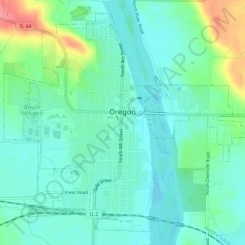
Oregon topographic map
Interactive map
Click on the map to display elevation.
About this map
Name: Oregon topographic map, elevation, terrain.
Average elevation: 223 m
Minimum elevation: 202 m
Maximum elevation: 285 m
Other topographic maps
Click on a map to view its topography, its elevation and its terrain.
Grand Detour
United States > Illinois > Ogle County
Grand Detour, Grand Detour Township, Ogle County, Illinois, United States
Average elevation: 213 m
Stillman Valley
United States > Illinois > Ogle County
Stillman Valley, Marion Township, Ogle County, Illinois, United States
Average elevation: 222 m
Rockvale Township
United States > Illinois > Ogle County
Rockvale Township, Ogle County, Illinois, United States
Average elevation: 239 m
Lost Nation
United States > Illinois > Ogle County
Lost Nation, Taylor Township, Ogle County, Illinois, United States
Average elevation: 223 m
Leaf River
United States > Illinois > Ogle County
Leaf River, Leaf River Township, Ogle County, Illinois, United States
Average elevation: 227 m
Byron
United States > Illinois > Ogle County > Byron
Byron, Ogle County, Illinois, 61010, United States
Average elevation: 226 m
Monroe Township
United States > Illinois > Ogle County
Monroe Township, Ogle County, Illinois, 61052, United States
Average elevation: 243 m
Monroe Center
United States > Illinois > Ogle County
Monroe Center, Monroe Township, Ogle County, Illinois, United States
Average elevation: 254 m
Rochelle
United States > Illinois > Ogle County
Rochelle, Flagg Township, Ogle County, Illinois, 61068, United States
Average elevation: 243 m