
Kingston topographic map
Interactive map
Click on the map to display elevation.
About this map
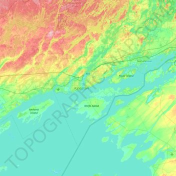
Name: Kingston topographic map, elevation, terrain.
Location: Kingston, Ontario, K7K 5J5, Canada (43.91025 -76.76890 44.55025 -76.12890)
Average elevation: 101 m
Minimum elevation: 69 m
Maximum elevation: 202 m
Other topographic maps
Click on a map to view its topography, its elevation and its terrain.
Cataraqui River
Cataraqui River, Pine Grove Road, Kingston, Ontario, Canada
Average elevation: 106 m
Belle Island
Belle Island, Kingston, Eastern Ontario, Ontario, Canada
Average elevation: 85 m
Bateau Channel
Bateau Channel, St Lawrence Avenue, Milton-on-the-St.-Lawrence, Kingston, Ontario, K7G 2V6, Canada
Average elevation: 75 m
Bexleygate Park
Canada > Ontario > Kingston > Bur Creek
Bexleygate Park, Cataraqui, Bur Creek, Kingston, Eastern Ontario, Ontario, Canada
Average elevation: 97 m