
Piedras Blancas topographic map
Interactive map
Click on the map to display elevation.
About this map
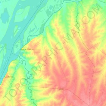
Name: Piedras Blancas topographic map, elevation, terrain.
Average elevation: 43 m
Minimum elevation: 10 m
Maximum elevation: 78 m
Other topographic maps
Click on a map to view its topography, its elevation and its terrain.
Alcaraz
Argentina > Entre Ríos > Distrito Alcaraz Segundo > Alcaraz
Alcaraz, Distrito Alcaraz Segundo, Departamento La Paz, Entre Ríos, E3138, Argentina
Average elevation: 80 m