Geolocate

Brampton East topographic map

Click on the map to display elevation.

About this map
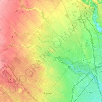
Name: Brampton East topographic map, elevation, terrain.

Location: Brampton East, Brampton, Caledon, Peel Region, Golden Horseshoe, Ontario, Canada (43.70829 -79.77176 43.84810 -79.63029)

Average elevation: 214 m

Minimum elevation: 152 m

Maximum elevation: 276 m

Other topographic maps

Click on a map to view its topography, its elevation and its terrain.
Heart Lake

Canada > Ontario > Peel Region > Brampton

Average elevation: 254 m

Bonnie Braes Park

Canada > Ontario > Peel Region > Brampton

Average elevation: 203 m

Wildfield

Canada > Ontario > Peel Region > Brampton

Average elevation: 225 m

Coleraine

Canada > Ontario > Peel Region > Brampton

Average elevation: 210 m

Heart Lake

Canada > Ontario > Peel Region > Brampton

Average elevation: 254 m

Gear up for your next adventure:

🚗Car Camping Gear - Equipment for vehicle camping
🔋Solar Power Banks - Charge your phone and GPS using the sun while deep in the bush
📦Crushproof Equipment Cases - Safe transport for sensitive surveying and mapping instruments
🐍Snake Gaiters - Protection against snake bites
📡Portable Emergency Radios - Stay informed about weather warnings and bushfire alerts

As an Amazon Associate, this site earns from qualifying purchases at no extra cost to you.